Dev Diary #35 - The Map 🗺️
What's happening / TLDR: Developer diaries introduce details of Espiocracy - Cold War strategy game in which you play as an intelligence agency. You can catch up with the most important dev diary (The Vision) and find out more on Steam page.
---
Welcome back after holiday break! As the tradition (of 34 installments...) suggests, we'll start with a lighter dev diary: this time, about the map in the map game.
[h2]Background Map[/h2]

Espiocracy implements old school 2.5D approach - player moves the camera in 3D at an angle, but all elements are 2D. In a classic trick, detailed 3D model of Earth was rendered into 248 two-dimensional textures. Not only the computation is done once and for all of the terrain (= better performance, lower requirements, easier development), we also get rather unique relief map of the world at resolution of 43x21 thousand pixels.
From day one, CIA maps were primary inspiration, which contributed to the choice of Robinson projection for the map. In a very topical accident frozen in time, the game actually uses... a CIA variant of Robinson projection, used in The World Factbook, which means that it's probably literally unique game map.
A few examples of zoomed in camera, starting with Indonesian labyrinth:

Korean Peninsula:

The Great Lakes region:

Tasmania:

And here's practical demonstration of the resolution, max zoom into Galápagos Islands:

These are more of an unintended harvest. Relief map remains always in the background and players preferring calm screen can switch to even more old school paper background:

Ultimately, they all serve the king of map types...
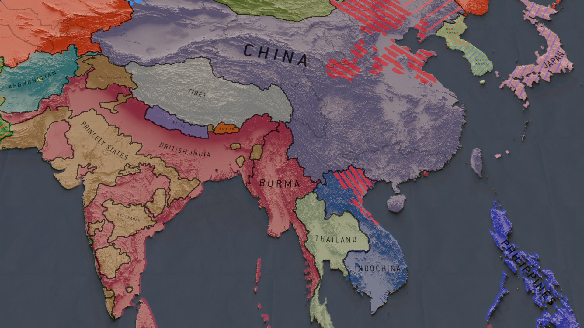
[h2]Political Map[/h2]

(This is the political map for the start date of March 5th, 1946. Protectorates and colonies share color with controlling countries. Thin west-facing stripes denote occupation (stripes have color of occupying state or states). Thick east-facing stripes denote territory controlled by subnational militant organization.)
Political map features de facto states. Following statehood criteria of Montevideo Convention...
...and gameplay criteria (every independent state is a player, has its own intelligence community, set of actors, available international actions etc), enriched by historical foresight, I made the following decisions:
A few closer glances:


While inclusion of states is a careful process, the game includes as many territories, enclaves, and islands as possible in the limited development time. Currently, there are 193 islands in Espiocracy. These provide very palpable geographical approach to the Cold War, from SIGINT installations to Argentina invading the Falklands or USA invading Grenada.
[h2]Gameplay[/h2]
High resolution of the map is not really an aesthetic choice - it is motivated by the gameplay and simulation. Instead of provinces, the world in the game is represented as 5100x2650 grid (with higher precision when needed). Operatives and actors travel in this coordinate system, cities or battles have precise points, rebel or armed conflict territory expands point by point, and most importantly: borders can be drawn in myriad of ways.
To assist alternate history and avoid bordergore, determination of borders (eg. in peace treaty) is supported by database of historical and natural borders. Here's an example of multiple layers of suggested borders in Germany (work in progress):

You can see here Weimar Republic states, administrative units of Nazi Germany, forward positions on V-Day, Anglo-French-American division, mountains, and rivers. The database will slightly evolve over the course of a campaign (eg. less significant & older borders will be forgotten - who remembers V-Day positions in 1995? - while new conquest or rebellions will leave new traces), although lines with the highest weight will remain unchanged (natural borders).
[h2]Final Remarks[/h2]
That was brief, visual, and light as promised. We'll certainly return to the map in the future - perhaps even two times more, since there's a lot more to talk about, from map modes to special hover UI or keyboard-based map traversal.
If you're not already wishlisting Espiocracy, consider doing it:
https://store.steampowered.com/app/1670650/Espiocracy/
There is also a small community around Espiocracy:

---
"One Soviet general, looking at a map of the territory Russia had acquired on the Karelian Isthmus, is said to have remarked: we have won just about enough ground to bury our dead" - William R. Trotter
---
Welcome back after holiday break! As the tradition (of 34 installments...) suggests, we'll start with a lighter dev diary: this time, about the map in the map game.
[h2]Background Map[/h2]
Espiocracy implements old school 2.5D approach - player moves the camera in 3D at an angle, but all elements are 2D. In a classic trick, detailed 3D model of Earth was rendered into 248 two-dimensional textures. Not only the computation is done once and for all of the terrain (= better performance, lower requirements, easier development), we also get rather unique relief map of the world at resolution of 43x21 thousand pixels.
From day one, CIA maps were primary inspiration, which contributed to the choice of Robinson projection for the map. In a very topical accident frozen in time, the game actually uses... a CIA variant of Robinson projection, used in The World Factbook, which means that it's probably literally unique game map.
A few examples of zoomed in camera, starting with Indonesian labyrinth:
Korean Peninsula:
The Great Lakes region:
Tasmania:
And here's practical demonstration of the resolution, max zoom into Galápagos Islands:
These are more of an unintended harvest. Relief map remains always in the background and players preferring calm screen can switch to even more old school paper background:
Ultimately, they all serve the king of map types...
[h2]Political Map[/h2]
(This is the political map for the start date of March 5th, 1946. Protectorates and colonies share color with controlling countries. Thin west-facing stripes denote occupation (stripes have color of occupying state or states). Thick east-facing stripes denote territory controlled by subnational militant organization.)
Political map features de facto states. Following statehood criteria of Montevideo Convention...
- Permanent population
- Defined territory
- Government
- Capacity to enter into relations with the other states
...and gameplay criteria (every independent state is a player, has its own intelligence community, set of actors, available international actions etc), enriched by historical foresight, I made the following decisions:
- Occupation zones - were consolidated where possible (eg. Allied-occupied Austria) or featured as separate states when setting up a conflict (eg. West and East Germany)
- Ephemeral states around 1946 which were protected by another country - featured (eg. Newfoundland and Labrador)
- Ephemeral states abandoned by other countries - represented below state level (eg. Second East Turkestan Republic)
- Participants of civil wars with fluid territory - represented below state level (eg. Viet Minh)
- De facto states with defined territory, invaded soon after 1946 - featured (eg. Tibet, Oman separated from Muscat, India divided into British India, Travancore, Hyderabad, Bhopal, Jammu and Kashmir, other princely states)
- Excessive number of small nearby states that acted or will soon act together - consolidated (eg. Trucial States, British West Indies, 500+ princely states except for the four above)
A few closer glances:
While inclusion of states is a careful process, the game includes as many territories, enclaves, and islands as possible in the limited development time. Currently, there are 193 islands in Espiocracy. These provide very palpable geographical approach to the Cold War, from SIGINT installations to Argentina invading the Falklands or USA invading Grenada.
[h2]Gameplay[/h2]
High resolution of the map is not really an aesthetic choice - it is motivated by the gameplay and simulation. Instead of provinces, the world in the game is represented as 5100x2650 grid (with higher precision when needed). Operatives and actors travel in this coordinate system, cities or battles have precise points, rebel or armed conflict territory expands point by point, and most importantly: borders can be drawn in myriad of ways.
To assist alternate history and avoid bordergore, determination of borders (eg. in peace treaty) is supported by database of historical and natural borders. Here's an example of multiple layers of suggested borders in Germany (work in progress):
You can see here Weimar Republic states, administrative units of Nazi Germany, forward positions on V-Day, Anglo-French-American division, mountains, and rivers. The database will slightly evolve over the course of a campaign (eg. less significant & older borders will be forgotten - who remembers V-Day positions in 1995? - while new conquest or rebellions will leave new traces), although lines with the highest weight will remain unchanged (natural borders).
[h2]Final Remarks[/h2]
That was brief, visual, and light as promised. We'll certainly return to the map in the future - perhaps even two times more, since there's a lot more to talk about, from map modes to special hover UI or keyboard-based map traversal.
If you're not already wishlisting Espiocracy, consider doing it:
https://store.steampowered.com/app/1670650/Espiocracy/
There is also a small community around Espiocracy:
---
"One Soviet general, looking at a map of the territory Russia had acquired on the Karelian Isthmus, is said to have remarked: we have won just about enough ground to bury our dead" - William R. Trotter